
When we began learning about the Tijuana/San Diego area, we were presented with the debate of whether there is one region or two distinctly varied urban identities here. I have taken on the approach that there is a symbiotic relationship between Tijuana and San Diego. The two are different in some ways, mostly those that have political and economical implications, but indeed the two are heavily reliant on each other. For example, the squatter housing of Tijuana is based off of the scrap and re-use of discarded San Diegan housing. With tens of thousands of Tijuana residents working in San Diego, the connection is thus apparent.
This symbiotic relationship goes beyond just the Tijuana/San Diego region, but also works in Tijuana itself between the informal and the formal. The informal economy (street vendors, window washers, newspaper sellers, taxi drivers, etc.) support and purchase their necessities through the formalized economy of shops and stores. The development also has this interesting relationship between the formal and informal. The informal housing starts as a squatter, or group of squatters build a temporary house or development using scraps from other more formalized housing developments. As this development becomes more entrenched, it starts to formalized and the people living there change their houses accordingly, replacing scrap garage door walls with concrete block. The scraps then are re-used by another informal house and the cycle begins all over again. The final example I will discuss deals with the infrastructure. People need a way to move from place to place, whether it be by automobile, bus, foot, or bike, people will need to go places. When the government doesn't build these such pieces of infrastructure, the people will build it themselves. In the Laureles Canyon, a perfect example is where on the west side of the canyon, the government built a concrete stair that traverses the canyon from top to bottom, however on the east side, there is no such path. People who live at the bottom of the canyon and need to make their way to the top for groceries, school, work, or to visit the doctor, have taken old unused automobile tires and filled them with dirt, creating a set of stairs and an infrastructure that the people needed but weren't given.
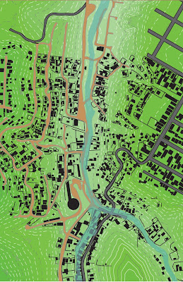
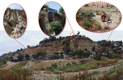
The existing condition of a portion of the Laureles Canyon, showing the roads (paved and dirt) and the river in a 100 year flood condition. The informal settlements occur at the bottom of the canyon, often IN the riverbed (center of image). An increasingly formalized community is quickly developing along the west side of the canyon. This area has nearly tripled in population over the last ten years. To the east, atop the caynon is a very formal middle income development that is where the schools, services, and retail all are located.
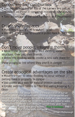
Above are the main ideas that I have based my framework plan around.

This is a diagram showing the existing movement of residents through this area. It became noticable the routes that they used to access the top of the canyon, which are built using the informal infrastructure of tire stairs previously mentioned.
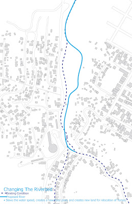
I am proposing moving the river's path slightly in this area, which will allow the creation of new land and space while also slowing the water's velocity during the flood stages, which will benefit not only the people of this area, but the Tijuana Esuary located on the US side of the border, where this river flows directly into.
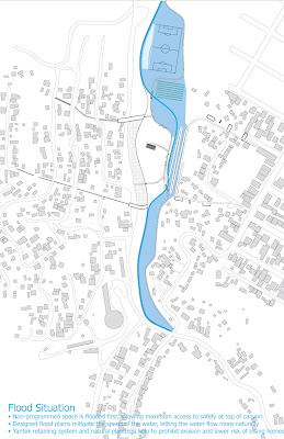
This diagram shows the flood condition with the newly moved river. This shows how the water ponds up, allowing a slower rate of water downstream. This also creats the opportunity for filtration at various points so that sediment and trash can be filetered out of the river incrementally instead of all at once, or worse not at all.
This is a diagram showing the condition of the site. The erosion that is occuring along the caynon because of the natual sandy soil in conjunction with the amount of rain and water drainage occuring. This creates a large amount of sediment in the river itself which if left unchecked will damage the estuary to which the water flows.
The erosion also creates dangerous living conditions, not only for those at the bottom of the canyon who are building on unsettled soil in a riverbed, but also those who are building on top of the cayon as the land on which they built slowly erodes right from underneath them. Over time and left unchecked these houses will eventually become dangerous and destroyed by the erosion.
Finally, the amount of trash left in the riverbed is astonishing. This is often seen as a local place for people to get rid of their trash, pollutes and damages the natural reserve on the US side.
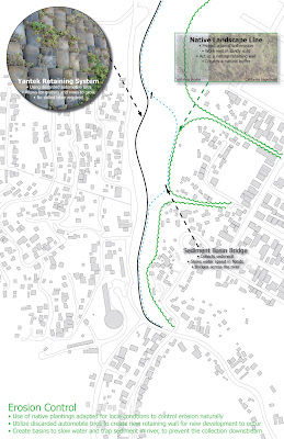
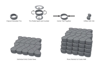
Erosion control is going to be handled as a way to help create stability in this area. Not only will this be the physical stability of the land, but also create a sense of stability and security of the residents who live in this area because no longer will they fear their house falling victim to nature's wrath. This will be done by planting a natural vegitation line along the east steeper side of the canyon. This vegitation will secure the land physically while creating a natural buffer along the canyon's slope. On the west side of the river, will be a man made retaining wall system that utilizes the discarded automobile tires as an asset as opposed to waste. Below is a diagram of how this system works. By creating this new retaining wall, new secured land is established in what use to be riverbed.

The above diagram shows of the 70 houses currently located in the riverbed can be relocated to the newly created land previously mentioned. This relocation allows those residents to keep their existing established social infrastructure including their jobs, where they shop for groceries, and their neighbors.
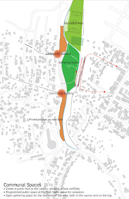
Through the moving of the river and the new retaining wall, new communal spaces are created that can be utilized for education, gathering, community events, community gardens, or recreation. The implementation of a new ramp that parallels the river also allows the beginning of a diaglouge between the residents on the top of the canyon with those on the bottom. By wrapping this ramp along the sides of the canyon, this creates a new infrastructure but also a public face to the canyon.
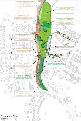
The framework plan from which I will work to develop a more detailed section in the next 10 days.
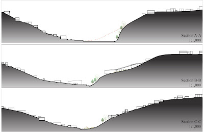
Finally, very diagramatic sections through the site.


 The existing condition of a portion of the Laureles Canyon, showing the roads (paved and dirt) and the river in a 100 year flood condition. The informal settlements occur at the bottom of the canyon, often IN the riverbed (center of image). An increasingly formalized community is quickly developing along the west side of the canyon. This area has nearly tripled in population over the last ten years. To the east, atop the caynon is a very formal middle income development that is where the schools, services, and retail all are located.
 Above are the main ideas that I have based my framework plan around.
 I am proposing moving the river's path slightly in this area, which will allow the creation of new land and space while also slowing the water's velocity during the flood stages, which will benefit not only the people of this area, but the Tijuana Esuary located on the US side of the border, where this river flows directly into.
 This is a diagram showing the condition of the site. The erosion that is occuring along the caynon because of the natual sandy soil in conjunction with the amount of rain and water drainage occuring. This creates a large amount of sediment in the river itself which if left unchecked will damage the estuary to which the water flows.
 Erosion control is going to be handled as a way to help create stability in this area. Not only will this be the physical stability of the land, but also create a sense of stability and security of the residents who live in this area because no longer will they fear their house falling victim to nature's wrath. This will be done by planting a natural vegitation line along the east steeper side of the canyon. This vegitation will secure the land physically while creating a natural buffer along the canyon's slope. On the west side of the river, will be a man made retaining wall system that utilizes the discarded automobile tires as an asset as opposed to waste. Below is a diagram of how this system works. By creating this new retaining wall, new secured land is established in what use to be riverbed.

 Through the moving of the river and the new retaining wall, new communal spaces are created that can be utilized for education, gathering, community events, community gardens, or recreation. The implementation of a new ramp that parallels the river also allows the beginning of a diaglouge between the residents on the top of the canyon with those on the bottom. By wrapping this ramp along the sides of the canyon, this creates a new infrastructure but also a public face to the canyon.
 Finally, very diagramatic sections through the site.


